Agriculture
RESTEC works in close cooperation with not only domestic but also international organizations, as well as space agencies, agricultural organizations, and other agencies of various countries in promoting the use of remote sensing in agriculture. We make use of our variety of networks and experience to provide information useful for problem solving and satellite services in an easy-to-use manner.
Assisting paddy rice farming using microsatellites
The PlanetScope microsatellite has significantly cut manufacturing costs compared to standard satellites. Notwithstanding, it has nearly the same performance (four bands: blue, green, red, near infrared; spatial resolution: 3.7 meters) and can make observations nearly daily through the simultaneous flying of 100 to 200 microsatellites. Thanks to microsatellites, a satellite monitoring system can be developed with high time resolution and high spatial resolution that was previously not possible with standard satellites.
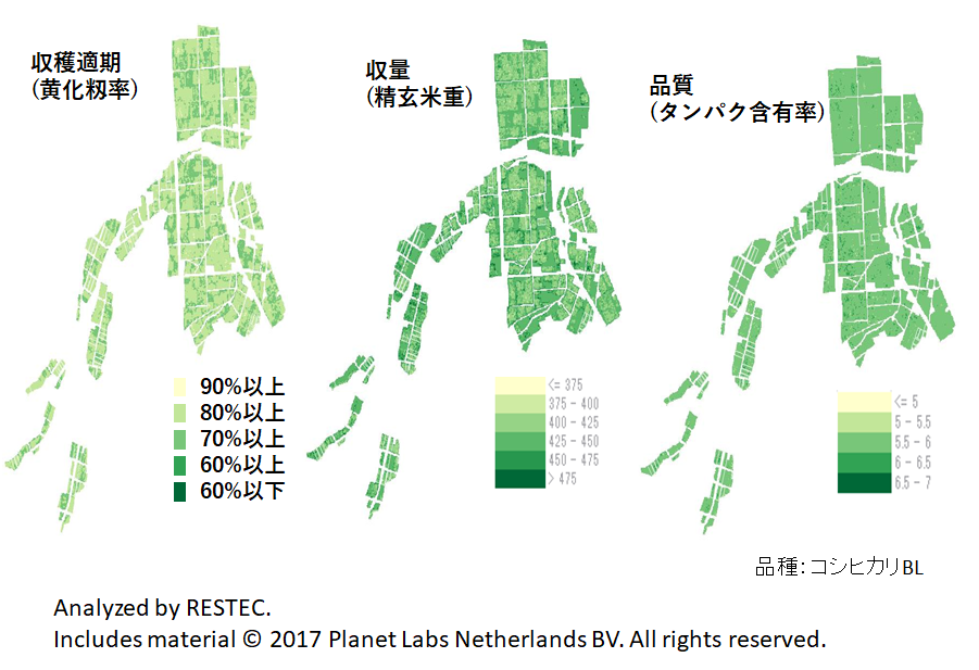
Using machine learning (support vector machine) as a system to assist paddy rice farming employing a group of microsatellites, RESTEC succeeded in accurately predicting the plant height, number of stems, and leaf color (SPAD value) of the Koshihikari BL and Mizuho no Kagayaki varieties during fertilization diagnosis from mid to late July as well as their suitable harvest period, yield, and quality in early September with a margin of error between single-digit percentage points to a dozen percentage points.
Estimating the Surface Area of Planted Rice Fields and the Prospects for Rice
Rice is eaten in many countries throughout Asia. In Japan, it is grown in well irrigated paddies, but rain-fed cultivation, which relies on water from rain alone, is common in countries throughout Southeast Asia. In such places, the surface area of rice fields that can be planted varies greatly depending on the rainfall that year. However, in reality it is difficult to carry out accurate surveys of the surface area of planted fields. This is where remote sensing can be used. The Synthetic Aperture Radar (SAR) is capable of carrying out surveys regardless of the time of day or weather conditions, and the surface area of planted rice fields can be estimated from the observation data gathered. (Figure A-3) RESTEC is also conducting research into estimating yields and applying this technology to other crops such as corn and sugarcane.
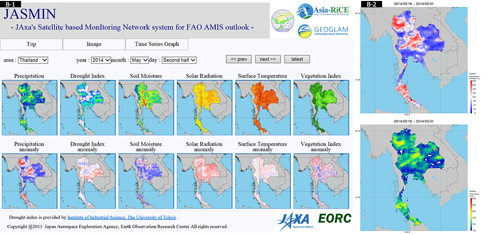
This is an example of information publicized on Jaxa’s Satellite Based Monitoring Network System (JASMIN) to allow estimating the status of rice crops in Asia.
(B-1) Shown above is the amount of rain and sunshine, the ground temperature, etc. Below, red indicates values that are high, and blue indicates values that are low relative to average annual readings. (B-2) Example of image showing the amount of rain. In this example, there are regions in Northern Thailand where it has rained more than in average years.


